All You Need To Know About YSR Jagananna Saswatha Bhoomi Hakku-Bhoomi Rakshana
21 Dec, 2020 17:52 IST|Sakshi Post
AMARAVATI: The ‘YSR Jagananna Saswatha Bhoomi Hakku-Bhoomi Rakshana’, a land resurvey across the State of Andhra Pradesh for giving permanent land rights to ensure dispute-free land holdings was launched on Monday by the Chief Minister YS Jagan Mohan Reddy.The digitisation of land records will eliminate any scope of manipulation which has become a significant menace after the bifurcation of the state.
The first survey stone was laid at Takkellapadu village of Jaggayyapeta mandal in Krishna district, as part of the pilot programme.
YSR Jagananna Saswatha Bhoomi Hakku-Bhoomi Rakshana
- This will be the first land resurvey conducted in the State 100 years after the first land survey was conducted during the British era.
- This is also termed as the first land survey done in the country by a state government.
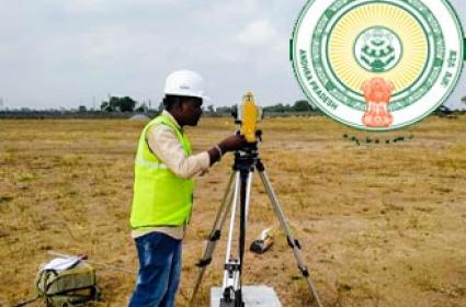
- The resurvey is being done using modern technology due to the vast tracts of lands to be measured.
- The State government will be conducted the survey along with the Survey of India.
- The survey will be taken up using hybrid methods like Continuous Operating Reference Stations (CORS) and drones.
- The resurvey will be conducted in 17,461 revenue villages, 47,861 habitations, 110 urban local bodies.
- For lands, house sites and houses, boundaries will be marked and title deeds will be issued to the land/house site/house owners.
- As many as 70 base stations have been set up across the State for conducting the resurvey.
- The resurvey will be held in three phases and completed by August 2023.
- The comprehensive resurvey would be conducted on 1.26 crore hectares in three phases in all districts.
- In the first phase, land resurvey will commence in 5,000 villages, at 6,500 villages in the second phase and in the third phase, 5,500 villages will be verified.
- 14,000 surveyors have been appointed for this purpose.
- In Krishna district, 1,500 staff will engage in conducting land resurvey in 332 villages in the first phase.
- The extent of the land in the district is 21,26,799 acres, of which 9,05,971 acres are government lands. Patta land is 14.53 lakh acres and the extent of land registered with Webland is 13.36 lakh acres.
- A team comprising two surveyors, a VRO and a VRA will conduct land resurvey in the village.
- Every survey number will be filmed using drone cameras and stored in digital format.
- Mobile tribunals have been set to up to resolve land disputes.
- Digitised cadastral (of a map or survey) showing the extent, value, and ownership of land,) maps will be prepared after the completion of the survey.
- Complete details of the lands in the village will be in the maps.
- Survey stones will be installed once the marking of land is completed.
- Digitised property register and title register and a register for complaints will be made available at the Village Secretariats.
- After the survey, records will be secured in a foolproof manner to ensure that no one can tamper with them
- The hard copy will be given to the landowners.
- A land titling card, which consists of a unique identification number, measurements of the property, name of the owner along with the photo and total area will be given to the owner after the survey.