Cyclone Phailin: Armed forces put on high alert
Defence Minister A K Antony has put the armed forces on high alert and asked them to be ready to provide all support in view of the impending cyclone Phailin, forecast to hit the Odisha and Andhra Pradesh coast on Saturday evening.
The IAF has deployed 24 aircraft including its transport planes such as Ilyushin-76, C-130J Super Hercules and the Antonv-32 along with 18 helicopters. The Defence Minister has directed the armed forces to be on high alert and asked them to be ready to move in for relief operations when required, a Defence Ministry official said.
Antony held discussions with Defence Secretary R K Mathur on the issue and has been briefed on all the steps that the armed forces would be taking to provide relief in the affected areas. The Vishakhapatnam-based Eastern Naval Command has kept multiple Indian Navy diving teams with inflatable rafts in standby mode at important locations which could be put into operations at short notices. Besides these, Navy has put some Chetak and UH-3H helicopters in standby for launching rescue and relief operations, if necessary. Disaster relief ships, as required, are also being kept by the Navy in readiness, the official said. Army has moved its Command and control element to Bhubneshwar under GOC Madhya Bharat (MB) Area.
One Engineer column from Bagdogra and one Medical column from Gopalpur have started moving to Bhubneshwar. Infantry columns are also on standby at Barrackpore. Coast Guard has sensitised state governments of Andhra Pradesh, Odisha and West Bengal requesting them to issue appropriate advisory to fishermen, shipping and local community.
West Bengal takes steps to manage aftermath of Cyclone Phailin
West Bengal government has dispatched disaster management teams to coastal areas of the state to tackle the aftermath of cyclone Phailin which is set to hit neighbouring Odisha by tomorrow evening. We have dispatched several disaster management teams to the coastal areas of West Bengal including Diamond Harbour and Digha, Disaster Management Minister Javed Khan said.
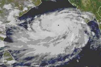
Khan said a helpline is being opened at the state secretariat. We have also asked civil defence teams to reach the coastal areas to meet any eventuality, he said. Cyclone Phailin, with a wind speed of 210-220 kmph, is turning into a super cyclone before making landfall tomorrow evening near Gopalpur in Odisha where the government has galvanised its machinery to deal with the impact and is evacuating people from low-lying and coastal areas.
Phailin unlikely to be like super cyclone of 1999: IMD
The very severe storm Phailin is unlikely to turn into a super cyclone like the one which hit the coastal areas of Odisha and Andhra Pradesh in 1999, the MET department today said. Although Phailin is on the border of being termed a super cyclone and has good resemblance of the 1999 storm, we have come to an understanding that it will not turn into a super cyclone. The storm will be around 210-220 kmph, but it is unlikely to intensify any further, said IMD Director General L S Rathore.
There are several parameters on which we measure the intensity of the storm. Of the several parameters, it also has to cross the 'T' level of 6.5, he said. T table is a system to measure the intensity of cyclones. Rathore said the coastal areas will start receiving very heavy to extremely heavy rainfall from Friday evening with a wind speed of 100 kmph.
It will accentuate by midnight and Saturday morning and cross up to 150 kmph. The storm is likely to subside by October 13 reducing to severe cyclonic storm and deep depression.
Odisha, AP brace for very severe cyclone, Phailin to hit coast tomorrow
Odisha and Andhra Pradesh today braced for the very severe cyclone that is expected to hit the east coast with winds gusting up to 220 kmph tomorrow evening, as lakhs of people were being evacuated to safer places and the military kept on standby.
Cyclone Phailin--the biggest cyclone in years to hit Odisha--is expected to make landfall near Gopalpur in Ganjam district in the eastern state after crossing an area between Paradip in Odisha and Kalingapatnam in AP.
Five districts were in the eye of the storm with IMD Chief Dr L S Rathore identifying Ganjam, Khurda, Puri and Jagatsinghpur districts in Odisha and Srikakalum in AP as those that is likely to be worst hit.
Rathore said the cyclone storm over east central Bay of Bengal currently lay 450 km southeast of Gopalpur and warned that it will be accompanied by a storm surge of up to three metres in the districts that will bear the brunt.
Cyclone Phailin is a very severe cyclone, Rathore said in Delhi. Rathore said the storm, which will hit the coast at 6 PM, is unlikely to develop into a super cyclone. Phailin was named by Thailand and it means sapphire in Thai.
The US Navy has also forecast that the wind speed will be above 240 kmph. Therefore, the cyclone is not less than any super cyclone for us, Special Relief Commissioner P K Mohapatra told reporters in Bhubaneshwar.
Mohapatra said the IMD had declared the 1999 calamity as a super cyclone as the wind speed had crossed 220 kmph. An estimated 9,885 persons were killed in the super cyclone that pummelled Odisha.
This time around, the wind speed is not much different than the previous super cyclone, he said.
Squalls with a wind speed of 45-55 kmph to 65 kmph have already started along Odisha coast since morning under the impact of Phailin. About 25 cm of rain has been predicted in 24 hours in the affected districts due to the cyclone.
The Odisha health department cancelled holidays and leave of all doctors in view of the impending situation even as the state government set a target of zero casualty and ordered speedy evacuation of people in seven coastal districts.
East Coast Railway planned to regulate and cancel about 24 passenger trains between Visakhapatnam and Bhadrak on the Howrah-Chennai Main Line route tomorrow.
Authorities began evacuating 64,000 people from the low-lying areas of three vulnerable districts in Andhra Pradesh, state Revenue Minister N. Raghuveera Reddy said.
Emergency food supplies and shelters for people expected to flee the heavy winds and rains were also being readied in the vulnerable districts. Disaster management teams were also kept in readiness.
Odisha government set a target of zero casualty and ordered speedy evacuation of people in low-lying areas in seven coastal districts which is home to lakhs of people.
Defence Minister A K Antony ordered the Armed Forces to be ready to move in to Odisha and Andhra Pradesh. Two IAF IL-76 aircraft have already airlifted NDRF teams and equipment to Bhubaneshwar. IAF assets have been kept on standby at various bases including at Raipur, Nagpur, Jagdalpur, Barrackpore, Ranchi and Gwalior. It has also kept two C130J aircraft, 18 helicopters, 2 AN-32s aircraft on a standby to move at a short notice besides asking its Eastern Air Command to coordinate relief operation with the task force positioned at Barrackpore.
The Navy, Airforce, NDRF, ODRF were ready for relief and rescue operation as soon as the cyclone hits the coast, Mohapatra said in Bhubaneswar. An anxious Odisha government held meetings and evaluated the developing situation. At least 28 teams of the National Disaster Response Forces are at the disposal of the Odisha government for evacuation and relief operations, a senior official said after one such meeting. So far eight teams of NDRF, reaching having 20 personnel, have been deployed in Puri district, the official said. Revenue and Disaster Management Minister S N Patro said district collectors have been told to complete evacuation of people by this evening. We do not want to take any chance, Patro said adding that shelters were ready.
The Collectors of all seven districts like Ganjam, Gajapati, Puri, Jagatsingpur, Kendrapara, Nayagarh and Khurda have been directed to start evacuation and ensure 100 per cent evacuation of people to cyclone and flood shelters and other safe places by today evening, said Patro. The Collectors of Bhadrak and Balasore districts have also been alerted, the minister said. Appealing to the people not to panic, Chief Minister Naveen Patnaik asked them to cooperate with the government in relief and rescue operations.
The IMD forecast a storm surge of 2.5 to 3 metres in Ganjam, Khurda, Puri, Jagatsinghpur and Srikakulam districts. A storm surge is a rise of the sea as a result of atmospheric pressure changes and winds associated with a storm. Gales with a speed of 205-215 kmph are expected when the cyclone crosses the coast, according to A P Revenue Minister N Raghuveera Reddy Sometimes the gale speed may even touch 235 kmph while heavy to very heavy rainfall of up to 25 cm is also likely under the impact, he told reporters in Hyderabad. The Minister said he spoke to Collectors of coastal districts and put them on high alert. Army, Navy and National Disaster Response Force personnel have already been positioned in vulnerable coastal districts while IGP (north-coastal zone) Ch Dwaraka Tirumala Rao has been asked to coordinate with other departments to ensure effective communications in case of emergency. In 1996, we had a super cyclone and Phailin is expected to be of the same intensity, Reddy said.